Identifying Where to Reforest After Wildfire
by Kat Kerlin, UC Davis
12/18/2020
In the aftermath of megafires that devastated forests of the western United States, attention turns to whether forests will regenerate on their own or not. Forest managers can now look to a newly enhanced, predictive mapping tool to learn where forests are likely to regenerate on their own and where replanting efforts may be beneficial.
The tool is described in a study published in the journal Ecological Applications by researchers from the University of California, Davis; U.S. Geological Survey (USGS), Cal Fire and the U.S. Forest Service.
“Huge fires are converting forested areas to landscapes devoid of living trees,” said lead author Joseph Stewart, a postdoctoral researcher at UC Davis and with USGS. “Managers need timely and accurate information on where reforestation efforts are needed most.”

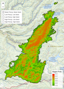
The POSCRPT tool produces spatial predictions of post-fire forest regeneration. Photo courtesy of UC Davis/USGS.
The tool, also known as the Post-fire Spatial Conifer Regeneration Prediction Tool (POSCRPT), helps forest managers identify within weeks after a fire where sufficient natural tree regeneration is likely and where artificial planting of seedlings may be necessary to restore the most vulnerable areas of the forest.
Read more here: https://www.ucdavis.edu/news/identifying-where-reforest-after-wildfire/
Read the Ecological Applications paper: https://esajournals.onlinelibrary.wiley.com/doi/10.1002/eap.2280