
Getting to know Kentucky
Kentucky is a located in the east south-central region of the United States. A significant portion of eastern Kentucky is part of Appalachia. Originally a part of Virginia, in 1792 Kentucky became the 15th state to join the Union.  Kentucky is the 37th most extensive and the 26th most populous of the 50 United States. Kentucky is known as the “Bluegrass State”, a nickname based on the bluegrass found in many of its pastures due to the fertile soil.
Kentucky borders seven states, from the Midwest and the Southeast. West Virginia lies to the east, Virginia to the southeast, Tennessee to the south, Missouri to the west, Illinois and Indiana to the northwest, and Ohio to the north and northeast. Only Missouri and Tennessee, both of which border eight states, touch more. Kentucky’s northern border is formed by the Ohio River and its western border by the Mississippi River. However, the official border is based on the courses of the rivers as they existed when Kentucky became a state in 1792.
Kentucky has a non-contiguous part known as Kentucky Bend, at the far west corner of the state. 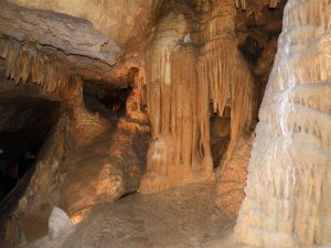 It exists as an exclave surrounded completely by Missouri and Tennessee, and is included in the boundaries of Fulton County. Road access to this small part of Kentucky on the Mississippi River requires a trip through Tennessee. The epicenter of the powerful 1811–12 New Madrid earthquakes was near this area, even causing the river to flow backwards in some places. Though the series of quakes did change the area geologically and affect the small number of inhabitants of the area at the time, the Kentucky Bend was formed because of a surveying error, not the New Madrid earthquake.
One of the major regions in Kentucky is the Bluegrass Region in central Kentucky, which houses two of its major cities, Louisville and Lexington. It is a land with diverse environments and abundant resources, including the world’s longest cave system, Mammoth Cave National Park, the greatest length of navigable waterways and streams in the contiguous United States, and the two largest man-made lakes east of the Mississippi River.
After Alaska, Kentucky has more navigable miles of water than any other state in the union. Kentucky is the only U.S. state to have a continuous border of rivers running along three of its sides—the Mississippi River to the west, the Ohio River to the north, and the Big Sandy River and Tug Fork to the east. Its major internal rivers include the Kentucky River, Tennessee River, Cumberland River, Green River and Licking River.
Though it has only three major natural lakes, Kentucky is home to many artificial lakes. 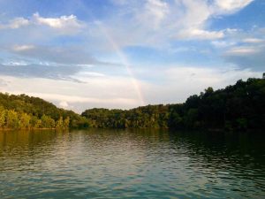 Kentucky has both the largest artificial lake east of the Mississippi in water volume (Lake Cumberland) and surface area (Kentucky Lake). Kentucky Lake’s 2,064 miles (3,322 km) of shoreline, 160,300 acres (64,900 hectares) of water surface, and 4,008,000 acre feet (4,944 Gl) of flood storage are the most of any lake in the TVA system.[29]
Kentucky’s 90,000 miles (140,000 km) of streams provides one of the most expansive and complex stream systems in the nation.
Kentucky has an expansive park system, which includes one national park, two National Recreation areas, two National Historic Parks, two national forests, two National Wildlife Refuges, 45 state parks, 37,896 acres (153 km2) of state forest, and 82 Wildlife Management Areas.